

Snow Canyon Loop
ROUTE SUMMARY
The Snow Canyon eBike Rentals recommended Loop Route consists of a smooth paved biking/pedestrian trail that is triangular in shape. On one side, it traverses from the bottom to the top of Snow Canyon State Park. On the next side, it travels fairly straight, with some rolling ups and downs with steeper spots along the Veyo highway (highway 18). The third side circles back along the north border of St. George along the Snow Canyon Parkway. The trail is smooth and paved, however there are a few steep grades (both up and down) that are best taken slowly.
We recommend you travel the loop in a clockwise manner, starting from our rental location and traveling from the South Entrance of Snow Canyon, up through the canyon, and continuing through the North Entrance of Snow Canyon. This allows you to experience Snow Canyon State Park traveling up the canyon in a more slow-paced experience and then travel downhill along the highway along the path.
About Snow Canyon State Park
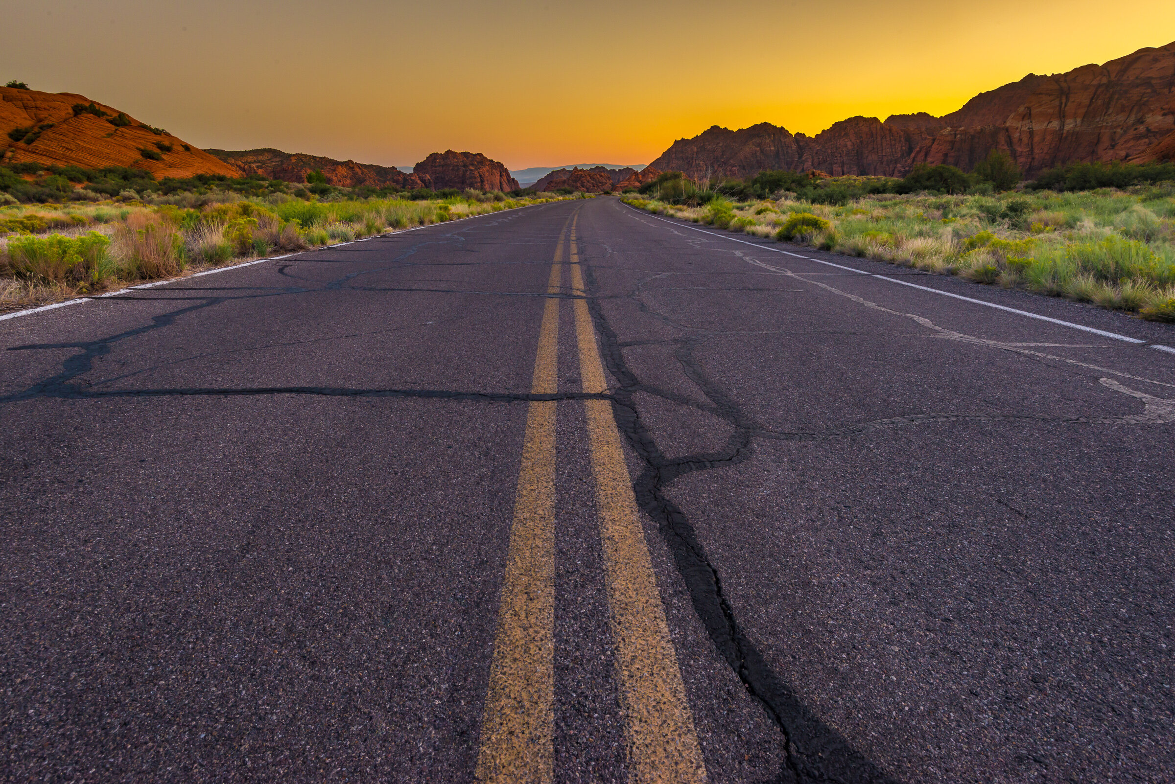
Snow Canyon State Park is a hidden gem in the southwestern corner of Utah. The beauty of the Navajo sandstone, both in its white rock formations, it’s steep red sandstone walls combined with the black lava flows is unique to Snow Canyon. The canyon has stunning formations that easily rival anything in Utah's national parks. Learn more about Snow Canyon.
In Snow Canyon, there are a lot of short hiking and walking trails that allow for playful exploration. Most of these trails are accessible right off the main route. There are also sand dunes to play in, rock-climbing routes in the south end of the canyon.
Snow Canyon State Park does require an entrance Fee. $5.00 for bicycle (1-8 bicycles).
Distance

18 Miles
If you do the complete loop.
Difficulty

7/10
If you use your throttle, this trail is not difficult at all.
Fees

REQUIRED.
Snow Canyon State Park Entrance Fee is required.
$5.00 / for 1-8 bicycles
Trail Type

Loop.
Paved Bike Path.
*except for 1 mile stretch in upper Snow Canyon State Park where you will ride on the road
Best Time of Day

Anytime is beautiful.
The canyon is beautiful in the morning and has less traffic.
It does get hot in the afternoons in the Summer.
Best Time of Year

Year round access.
Spring and Fall are optimal.
Summer is great, just be careful of hot afternoons.
Winter is fine also, but cooler in the morning and evening.
Group Limit

No limit.
The Snow Canyon State Park charges for a group of 1-8 bicycles.
Be considerate of other users.
Average Ride Time

This ride can be done in as little as 2 hours. (If you don’t stop riding)
We recommend taking your time and exploring Snow Canyon.
Average time for this ride is 4 hours. (Including short stops / rests / picture taking / lunch )
Restroom Facilities

Vault toilets
There are vault toilets available at the Park Visitor Center, Lower and Upper Galoot Parking lots.
Once out of Snow Canyon there are no facilities.
Water Available

Limited
There are water spigots at the Park Visitor Center, Lower and Upper Galoot Parking lots.
Outside of Snow Canyon there are no facilities.
Trail Conditions

Paved Bike trail
Asphalt, Concrete
Sun Exposure

Full Sun
There are a few small trees in Snow Canyon, but not much shade.
In the mornings, there may be shade in the lower part of the canyon as the sun is below the cliffs.
Detailed Route Description
This route description will include the hikes and attractions that are located in Snow Canyon State Park. We included the basic hiking and walking trail information in case you want to stop, lock up your eBike, and explore. Of course you can ride your eBike the entire route without stopping, but there are a lot of fun areas along the route where stopping, taking pictures and exploring will add to your experience. The hiking trail information is brief, but there are links to the park website if you are looking for more details.
Start Here
It all begins here at the Snow Canyon eBike Rental location. (www.RideSnowCanyon.com)
1098 Mesa Vista, Ivins, Utah 84738
Begin Route
Pedal north towards the roundabout (approx 300 yards). Travel through the roundabout to get onto the paved black path on the right (East) side of the road heading towards Snow Canyon State Park.
*Be careful as you go through the roundabout as there can be busy traffic. We recommend using your throttle to speed through, or else getting off your bike and using the crosswalks.
Once on the black path, head toward Snow Canyon State Park (straight toward the red cliffs). There are plenty of road signs pointing the way.
Stay on the path. You will make a small climb and notice the ‘Snow Canyon State Park’ sign on your right.
Johnson Canyon Hike & Parking Lot
On the left side of the road will be a parking lot. This is overflow parking for the State Park as well as the parking lot for the Johnson Canyon Hike. The hike actually starts on the right (East) side of the road and bike path.
Johnson Canyon Hike – (Closed annually from March 15 to September 14) – 2 miles. Easy. Level with some rocky slopes and steps. Leads to a sheltered canyon of willow and cottonwood, winding through lava flows and red rock to an arch spanning 200 feet.
Park Entrance Booth/Whiptail Trail
You are now entering the State Park. You will need to stop at the entrance booth to pay for a bicycle day use pass.
Park Fee: $5 for 1-4 bikes (prices subject to change)
Once you are in the park, follow the black path as it winds on the west side of the road. This is the start of the the ‘Whiptail Trail’ that traverses through Snow Canyon.
Jenny’s Canyon Pulloff & Hike
As you look down to your right, there will be a small pull-off on the East side of the main road. This is the starting point for Jenny’s Canyon. One-half mile. Easy. Level with few slopes and steps. This great children’s trail leads to a short, sculpted slot canyon.
*This trail is only accessible from the road, and not from the ‘Whiptail Trail’. If you want to acess it, you must go back to the entrance booth and get on the main road, or go to the Sand Dunes parking lot and get on the main road.
Sand Dunes

The Sand Dunes are on your right. There are a couple places where you can sit on a bench and overlook them.
Lock your bike and explore, but please don’t take your rented eBike out on the dunes.
One-half mile. Easy. Deep sand with some slopes. Trail leads to a large expanse of red sand serving as a giant sandbox and play area for children of all ages.
At the north side of the sand dunes, you will come to a parking lot.
Restooms, picnic tables, and water available.
West Canyon Road Trailhead
Just past the Sand Dunes parking lot you will see a dirt road on the west side. This is the start of the West Canyon Road.
We DO NOT recommend taking this road on your rented eBike. This is more of a Mt. Bike friendly trail.
8 miles (4 out / 4 back). Easy. Gravel and sand surface. Fairly level. Trail follows a maintenance road winding past dry washes and towering cliffs to the head of present-day Snow Canyon.
Dry Wash
You will pass through a dry wash. There will be some larger trees where you can pull off and enjoy some shade. Hop off your eBike and explore up and down the wash.
*This dry wash becomes a flash flood area during rain storms. Be careful if it is raining.
Pioneer Names on Cliff Wall
On the right side of the road (East side) you will notice some steep high cliffs. As you look into that area, you can often times see rock climbers on the cliff wall.
You can park and lock your eBike to the wood post fence rail. Cross the road, and follow the walking trail to see some names that were put on the cliff wall. They are located in one of the arched undercuts on the cliff wall.
One-half mile. Easy. Fairly level with some steps and slopes. This crescent-shaped trail passes pioneer names, written in axle grease, dating back to 1881.
Hidden Pinyon Hike & Parking lot
You will pass a parking lot on the left (West) side of the trail. This is the trailhead of the Hidden Pinyon hike.
1.5 miles. Moderate. Rocky slopes and deep sand. Drop-offs. This self-guided nature trail highlights geological features and native plants of the park.
Campground / Park Office / Visitor Center
On the right (East) side of the road will be the main campground / Park Office / Visitor Center. You can get park information and maps here.
It’s always fun to ride around the campground loop and pick out your next campsite.
Restooms, picnic tables, and water available.
Lower Galoot Parking & Walking area
On the right (East) side of the road will be a small parking lot. You can stop here and take a break to explore.
*We recommend bypassing ‘Lower Galoot’ and continuing on to ‘Upper Galoot’. It has a bigger picnic area, and easier access to explore the Red Rock slabs.
Restooms, picnic tables, and water available.
Upper Galoot Parking & Walking area


On the right (East) side of the road will be a small parking lot. You can stop here and take a break to explore.
Restooms, picnic tables, and water available.
*At this point, the paved path ends. (End of ‘Whiptail Trail’). You will need to travel on the road for the next mile. Travel on the right shoulder and be careful of passing cars.
Petrified Dunes
On the left (West) side of the road will be a small parking lot. This is the trailhead for Petrified Dunes.
1.2 miles. Moderate. Some steep slopes, uneven surfaces. This route crosses massive Navajo sandstone outcrops and sand dunes frozen in time.
Butterfly Trail & Parking lot
On the left (West) side of the road will be a small parking lot. This is the trailhead for the Butterfly Trail.
2 miles. Moderate. Some steep slopes, steps and uneven surfaces. Winding along the west side of Petrified Dunes, this trail leads to West Canyon Overlook and lava tubes.
Lava Flow Trail & Parking lot
On the left (West) side of the road will be a small parking lot. This is the trailhead for Lava Flow Trail.
2.5 miles. Moderate. Uneven surfaces. Hike through a jumbled lava field, the vivid remains of a long-ago volcanic eruption.
The Hill Climb
This next stretch will get steep. About 1/3 mile.
We recommend using your Pedal Assist, and throttle to help getting up this grind. This is where the eBike’s power really help. Be sure to smile as you pass those on conventional bikes. ;-)
North Park Entrance Both
The North Park Entrance Booth may not have anyone inside, depending upon the day and time of your ride. If it is occupied, they may request that you stop and show your entrance pass. If not, keep pedaling until you get to the top of the hill and the next parking lot.
Parking Lot
You made it to the top! Great job. This is the highest elevation that you will reach on this loop route. It’s all downhill from here. There will be ups and downs, but from here you will be descending back to the valley below.
The trail starts again from this parking lot. Locate the paved path heading South and follow it.
Highway Path
This section of the route is pretty straight with a slight downhill. You will be riding parallel to Highway 18. Enjoy the scenery and the fresh air. Stay on the path.
Overlook
On your right will be a dirt road that goes out to the cliff edge. You can ride out on this short dirt road to a point where you can look out over Snow Canyon from above. The road may be sandy and difficult to navigate. If you don’t feel confident, then don’t take this trail. You will be able to overlook the canyon as you keep traveling the route. Don’t stress it.
Winchester Hills
As you continue along the paved path, you will pass by the small community of Winchester Hills. There aren’t many services here. Stay on the path and keep heading south.
Steep downhill Stretch
As you start this next section, you will want to stop and test your brakes. You are entering a section where there are some steep downhills. If you don’t feel comfortable riding them, then hop off and walk. Better safe than sorry.
Please be careful and monitor your speed. You don’t want to crash on this section.
There are some fun rollercoaster type drops and rises on this section.
Be ready to transition from braking to throttle to get up and down some of these hills.
Maintain control and have fun.
Climbing area Parking & Trail
On your right there will be a parking lot. This is the start of some of the Paradise Canyon trails and rock climbing area. Stay on the path.
Snow Canyon Parkway Intersection
At this intersection, you will want to take a right (head West) and follow the paved bike path as it runs along the Snow Canyon Parkway.
You are now back in the city of St. George, so there will be traffic and more riders and walkers on the paved path.
Stay on the path as it crosses the cross streets.
Fish Pond
You will come to a fishing pond on your right. Stop here and take a break.
There are several benches here to sit and watch the fishermen.
If you go down through the parking lot, you will find a small tunnel going under the road and over into the Snow Canyon Softball complex. You can sit and watch a game, or lay in the grass and just take a break under some nice shade trees.
Just make sure to backtrack and get back on the paved path when leaving.
Restooms, picnic tables, and water available. (seasonal)
Entrada Neighborhood
Keep following the path. You will be traveling next to the ‘Entrada’ neighborhood.
“Wild Horse” Roundabout
Be sure and get some pictures as you pass this unique and beautiful roundabout. Notice the sculptured horses and native americans on both sides.
You are on the home-stretch. Almost done.
Ivins Roundabout
This is where the Snow Canyon loop ends. If you’ve navigated correctly, this is where you started on the path.
End Here
Make your way through the Ivins roundabout or use the crosswalk, and head back to the Snow Canyon eBike Rentals location.
We are located approximately 300 yards south of the Ivins roundabout.
You made it. You completed the Snow Canyon Loop.